Spirit of Fuerteventura

Lifestyle Magazine & Travel Guide

You can start the track in the village or a couple of km further, close to the dried river bed (Barranco). You follow this barranco till the end to reach the sea for a refreshing moment. But do not swim out, as there are strong currents! Approx. distance: 9 km, approx. elevation: 178 m
Read more...
A nice walk along the cliffs and sandy beaches on the West side of Fuerteventura. Also achievable in the summer for adults when regular "cooling" periods in the sea are respected. An extended family walk in the winter. Approx. distance: 5 km, approx. elevation: 33 m
Read more...
The track starts in the village and goes west in a dried river bed (Barranco) to end up in a parking lot, next to the museum about the ancient village "Atalayita". You can visit the ruins of this village and walk up the small nearby volcano. The way back is mainly in a wide barranco. Approx. distance: 8,4 km, approx. elevation: 63 m
Read more...
You can start your walk from the village or from the beach towards the tiny island "el islote" and end up North till the cliffs and the sea come together. Amazing views over the steep mountains and the impressive waves. STRONG CURRENTS - DO NOT SWIM OUT! Approx. distance: 7,7 km, approx. elevation: 66 m
Read more...
Attention: we strongly disadvise to walk this track during stormy weather or when big waves are hitting the West-side of Fuerteventura. The walk will take you from La Pared through the sandy part of the Natural Park and along the shore on your way back. There is a small sandy beach halfway the track where you can enjoy a refreshing paddling. STRONG CURRENTS! DO NOT SWIM! You will see impressive shapes of sand, carved by nature.Approx. distance: 7,1 km, approx. elevation: 90 m
Read more...
An impressive walking track for the entire family, although children must be kept at hand at all times: steep cliffs! The proximity of the massive and bare rocks creates a sense of futility. Jean de Bethencourt and his crew came along here about 600 years ago when conquering the island. Approx. distance: 1 km, approx. elevation: 75 m
Read more...
You leave the road before arriving to Ajuy and follow the track till the Barranco de la Peña. Here you go left till the rocky beach. The "Rocky Gate" will welcome you for a refreshing rest.Approx. distance: 3 km - Approx. elevation: 60 m
Read more...
The track follows the coast line and connects the two villages, passing several valleys and small beaches that offer a welcome refreshment.Approx: Distance: 6,9 km – Approx. Elevation: 65 m
Read more...
The track is running through one of the most impressive landscapes of the island. The impressive rocks, the tiny chapel of the patron saint of Fuerteventura and the small path will give you a very special sensation.Approx: Distance: 3,57 km – Approx. Elevation: -85 m
Read more...
The track starts with a light slope towards a platform with nice views over Lajares, Villaverde and the distant dunes. The short climb (approx. 100m) to the summit of the volcano is somewhat heavy, especially when it is hot, but is also doable for kids over 12. From here you have a good view over the North Shore of Fuerteventura and over Lanzarote. The way back is light.Approx. distance: 4,9 km / Approx. elevation: 128 m
Read more...
The track is running through the very southern part of Fuerteventura. You pass an old (1963) military airfield without buildings and go North to the shore to see the impressive erosion, the result of the brutal forces of the waves. You cross the island to the South again and return via some beaches.Approx: Distance: 12,8 km – Approx. Elevation: 125 m
Read more...
The track starts in a dried river and goes up to a platform. Then you go East on a shoulder to reach the top. Tip: start very early in the morning so that you have reached the top when the sun rises: unforgettable moments!Approx: Distance: 8,2 km – Approx. Elevation: 240 m
Read more...
The track starts on an asphalted road that you will leave soon for a dirt track. You will walk on a schoulder with superb views on the valley and finally get to the top with astonishing views over the central area of Fuerteventura. On the way back you will pass the statues of the two ancient kings – Guize and Ayose – and the ruins of the convent San Buenaventura. Approx. distance: 6,7 km, approx. elevation: 267 m
Read more...
You can start your walk from the village or from the beginning of the dirt track. The ascend starts slow, but increases rapidly. You will cross some dry river beds (Barrancos) to reach the top with nice views over the central area of Fuerteventura. Approx. distance: 4,1 km, approx. elevation: 417 m
Read more...
The track will bring you close to the highest mountain of the area and will pass next to a re-forestation project before you will reach the first capital of the island.Approx: Distance: 9,3 km – Approx. Elevation: 460 m
Read more...
The track will bring you almost to the top from where you can enjoy a superb view over the North of Fuerteventura.Approx: Distance: 1,5 km – Approx. Elevation: 160 m
Read more...
The track will bring you almost to the top from where you can enjoy a superb view over the North of Fuerteventura.Approx: Distance: 1,9 km – Approx. Elevation: 54 m
Read more...
The track passes the old agricultural area of the island and you can enjoy some old architecture. The volcano La Gairia is almost omnipresent during this walk. Approx: Distance: 6 km – Approx. Elevation: 109 m
Read more...
Attention: steep slopes, we strongly disadvise to walk this track with children or with people who have fear of height.The track leads you to a barranco (gorge) that ends on very special shapes of sand, carved by the elements water and wind. Further you will come to a Caldera (mouth of a volcano) which will give you some impression of nature's power. The way back is over a sandy part of the Natural Park.Approx. distance: 4,0 km, approx. elevation: 80 m
Read more...
N 9,0 km 178 m A track over dirt roads and pavements with lava rock. Starting in the northern part of the city of Corralejo, via the vulcano Calderon Hondo to Lajares. Approx. length: 13 km, approx. elevation: 212 m
Read more...
A sandy hiking track, starting from La Pared to Risco del Paso near Costa Calma. A part of this track is the shortest distance to cross the island from one side to the other. Approx. distance: 11 km - approx. elevation: 130 m
Read more...
A medium walk from Morro Jable to Playa de la Barca. Most of the time you will be walking along the shore. Approx. distance: 12 km - approx. elevation: -70 m (downhill)
Read more...
The track is running through one of the most productive agricultural areas of the island and comes close to the reforestation project.Approx: Distance: 6 km – Approx. Elevation: 270 m
Read more...
The track crosses the Betancuria mountain range. From the top you will enjoy the surrounding landscapes which are one of the oldest formations of the island.Approx: Distance: 5,6 km – Approx. Elevation: 340 m
Read more...
The track climbs steeply on the mountain Cardón, one of the most emblematic natural elements of Fuerteventura. From the end point one has a magnificent view over the West coast and the plains of Fuerteventura. Approx: Distance: 2,3 km – Approx. Elevation: 200 m
Read more...
The track starts at the east entrance of Cofete and goes relatively flat for a while. After about 2km you will begin a steep climb to the shoulder of the pass. Here – halfway – you can rest and enjoy the marvellous views back to Cofete or to the valley going to Morro Jable. The second part of the descent can be hot.Approx. distance: 6,3 km - Approx. elevation: 290 m
Read more...
You can climb this volcano from 2 sides: West or East or make a round trip. The track has some steep parts and on the top you can overview Corralejo, Lobos, the North-West coast and Lanzarote.Approx: Distance: 3 km – Approx. Elevation: 180 m
Read more...
This track crosses the narrowest part of the island from East to West and runs through a sandy area. You get a good impression about the differences in power of the waves between East and West.Approx: Distance: 3,3 km – Approx. Elevation: 52 m
Read more...
The track, which starts at the FV02 secondary road from Jandía to Costa Calma, will bring you to a famous view point which overlooks the impressive Barlovento coast line. The track is a mix of sandy and rocky road. Approx: Distance: 5 km – Approx. Elevation: 204 m
Read more...
The track is running within the Jandia Natural Reserve and offers from the highest point of the island some splendid views over the West coast.Approx: Distance: 6,4 km – Approx. Elevation: 680 m
Read more...

Senderismo en Fuerteventura - individual o en un grupo guiado - le permitirá descubrir la belleza de Fuerteventura. Al hacer parte de un grupo guiado también tendrá la oportunidad de recibir mucha más información sobre la historia, la naturaleza y la cultura de la isla. Encuentre aquí donde reservar una visita guiada.

Para más info sobre el senderismo: haz click aquí

The main complaint about Fuerteventura, expressed by tourists at the front desk of the hotel is: " When will the wind finally lay down?" or "Does it always blow that much here?" Many groan about the wind, not knowing that it would be unbearably hot here in the summer without those tradewinds.

Already in the ancient Greek times they called these islands "the fortunate islands, gently stroked by the eternal wind" or "those Elysic climes", and also Beethoven's "Elysium" comes from the "Alisios", the tradewinds.

Leer más...

Madeira and La Palma are hiking destinations - Fuerteventura is sunbathing and swimming. Because many tourists think that there is nothing else on this "heap of rubble". Very recently the Hiking tourism has discovered Fuerteventura: The approximately 1.700 km2 of "rubble" include 13 Natural protected areas with a total surface of 48.000 hectares! And unlike other islands, most of these areas here are interconnected and allow hiking without the usual road signs.

Leer más...

La magnífica montaña de Tindaya en forma de pirámide es realmente tentadora, pero primeramente tendremos que obtener un permiso de las autoridades locales para poder subir a ella. El guía nos recográ en la base de la "Montaña de las Brujas", como se la conoce localmente.

Leer más...

We start from Tiscamanita with a visit to the mill museum where they used to grow many sorts of grain in the past. We then head to the East. We enter the volcano through the solidified lava river from the protected volcano Jaina (463m). The Tabaibas grow along the path to the beautiful view over the red soil of the “Womens Lagune”, the Malpais Chico and the Malpais Grande with the 2 Picon volcanoes.

Leer más...

El volcán "Montaña Arena" se reparte entre Villaverde y La Oliva. Es el último volcán que hizo erupción, hace unos 4.000 años. Gracias a Dios, está protegido como "Área Natural".
La caminata comienza en la Villa Volcana a través de un viejo camino ganadero, a lo largo de campos rodeados por muros de piedra seca y que nos permiten disfrutar de hermosas vistas de la cadena de volcanes del norte, el islote pirata de Lobos, Lanzarote, y las dunas de Corralejo.

Leer más...

Fuerteventura Tours offers Aloe Vera tours, walking to Cofete and individual hiking tours. Groups are between 6 and 8 people. Included in the package are shuttle to and from hotel and insurance. Reservation only dy direct booking or through hotel reception.

Leer más...

Time-for-Nature is located in the South of Fuerteventura but offers hiking tours all over the island. Everyday there is another tour organised. They have a Get-Back-Money policy if you didn't like the tour.

Leer más...

Caminata is the hiking company of registered hiking guide Hannelore and offers more than 25 different hiking routes on Fuerteventura. She is based in the North of the island but guides groups all over Fuerteventura. Explanation about the history, nature and geography of the island is given in different languages.

Leer más...

Caminata a través de la antigua ruta de camellos hasta la cima de la Montaña de Escanfraga, 529m de altitud.

Si te apetece una caminata media-fuerte a las antiguas zonas de cultivo de grano en el cráter de la Montaña Escanfraga en Villaverde, esta puede ser una buena elección. Te recogeremos en tu hotel o apartotel y te conduciremos hasta Villaverde. La subida es suave y durante unos 90 min siguiendo una pista serpenteante. En la cima serás recompensado por unas maravillosas vistas de Corralejo, Lobos, Lanzarote, las dunas, la montaña de Tindaya y unos 20 viejos volcanes más. Se ven también los pueblos de Villaverde, La Oliva, Lajares y El Cotillo. Y hacia e l sur podrás ver mas poblaciones así como miles de antiguos campos agrícolas.

Leer más...

Dos maravillosas rutas por los Caminos Reales.

 Betancuria es en el centro de Fuerteventura. Ambos caminos, uno más corto que el otro, te mostraran la parte más verde de la isla. Descubrirás la primera capital de la isla y las montañas más antiguas de Canarias y disfrutaras de unas maravillosas vistas de la isla. Podrás oír el viento azotar los arboles del bosque local, y la agradable zona de barbacoa que allí se encuentra nos invitara a disfrutar del picnic que hemos preparado. Tras haber saboreado las especialidades locales, el camino más corto nos llevara de vuelta a Betancuria, mientras que el recorrido largo nos llevara a través de un valle de palmeras hasta Vega del Rio Palma. La vegetación que se encuentra alrededor del lago artificial es abundante. Tu guía te explicara la historia, geología, cultura, etc. La vuelta a Betancuria se hace a lo largo del lecho de un rio seco. Ahí tendrás tiempo para visitar este histórico lugar y tomar un vino o cerveza. Ambos recorridos ofrecen preciosas vistas para fotografiar.

Leer más...

El viaje continúa por los viejos caminos de rebaños de Morro Jable a Cofete, en la salvaje costa Oeste. Empezamos en el campo de cactus en el "Gran Valle", bajando un par de kilómetros por el camino de tierra de Morro a Punta de Jandía. La caminata comienza con una ligera pendiente en la recién restaurada pista (arena y piedra). Hubo un tiempo en el que esta era la única conexión con la costa oeste y con Cofete.

Leer más...

La excursión nos llevará a un tipo especial de volcán: un volcán respiradero. Está formado por un ascenso lento de lava en la columna central de un cráter ya existente, pero sin salidas principales. Una vez que la lava se solidifica dentro del cono de ceniza, se forma un conducto vertical de basalto que permanecerá erguido mucho tiempo después de que la ceniza de alrededor haya sido erosionada por los elementos naturales.

Leer más...

Comenzamos en Tiscamanita con una visita al Museo del molino donde en el pasado se cultivaban muchos tipos de grano. A continuación nos dirigimos hacia el este. Entramos en el protegido volcán Jaina (463m) a través del río de lava solidificada.

Leer más...

Vallebrón, un paisaje protegido con un pueblo situado en un valle en forma de “U” con relieve de cuchillo, que antiguamente era un valle muy fértil con cientos de gavias y con muchos pozos.

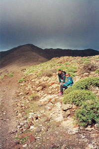
Empezamos la subida 300 m por debajo del nuevo mirador y seguimos en dirección a la montaña Muda (lugar de interés histórico por albergar un yacimiento).
Leer más...

Pico-de-la-Zarza-2Escalar la cumbre más alta de Fuerteventura: "Pico de la Zarza" (807m)
La ascensión se hace sin problemas gracias a una amplia pista que se encuentra en buenas condiciones. Sin embargo, se necesita estar en algo de forma física para subir desde el nivel del mar a los 807m. Metro tras metro, cada vez estamos más cerca de una vista (literalmente) asombrosa. Si vuelves tu espalda podrás ver los complejos hoteleros y el faro de Morro Jable.
Enormes arbustos de tabaibas crecen a lo largo de la pista junto a bellas gageas luteas. A medida que subimos estas plantas son más abundantes gracias a la creciente humedad proporcionada por un mar de nubes.

Leer más...

Hay 327 invitados y ningún miembro en línea

Visitas
8123866

biking-hiking2

Caminata - Senderismo & Bici Todoterreno

BIDI Fuerteventura

BIN06 PORTADA

BIS06 PORTADA

BIDI Fuerteventura

Una completa guía de la isla en 6 idiomas.
Online Edition