Spirit of Fuerteventura

Lifestyle Magazine & Travel Guide

You can start the track in the village or a couple of km further, close to the dried river bed (Barranco). You follow this barranco till the end to reach the sea for a refreshing moment. But do not swim out, as there are strong currents! Approx. distance: 9 km, approx. elevation: 178 m
Read more...
A nice walk along the cliffs and sandy beaches on the West side of Fuerteventura. Also achievable in the summer for adults when regular "cooling" periods in the sea are respected. An extended family walk in the winter. Approx. distance: 5 km, approx. elevation: 33 m
Read more...
The track starts in the village and goes west in a dried river bed (Barranco) to end up in a parking lot, next to the museum about the ancient village "Atalayita". You can visit the ruins of this village and walk up the small nearby volcano. The way back is mainly in a wide barranco. Approx. distance: 8,4 km, approx. elevation: 63 m
Read more...
You can start your walk from the village or from the beach towards the tiny island "el islote" and end up North till the cliffs and the sea come together. Amazing views over the steep mountains and the impressive waves. STRONG CURRENTS - DO NOT SWIM OUT! Approx. distance: 7,7 km, approx. elevation: 66 m
Read more...
Attention: we strongly disadvise to walk this track during stormy weather or when big waves are hitting the West-side of Fuerteventura. The walk will take you from La Pared through the sandy part of the Natural Park and along the shore on your way back. There is a small sandy beach halfway the track where you can enjoy a refreshing paddling. STRONG CURRENTS! DO NOT SWIM! You will see impressive shapes of sand, carved by nature.Approx. distance: 7,1 km, approx. elevation: 90 m
Read more...
An impressive walking track for the entire family, although children must be kept at hand at all times: steep cliffs! The proximity of the massive and bare rocks creates a sense of futility. Jean de Bethencourt and his crew came along here about 600 years ago when conquering the island. Approx. distance: 1 km, approx. elevation: 75 m
Read more...
You leave the road before arriving to Ajuy and follow the track till the Barranco de la Peña. Here you go left till the rocky beach. The "Rocky Gate" will welcome you for a refreshing rest.Approx. distance: 3 km - Approx. elevation: 60 m
Read more...
The track follows the coast line and connects the two villages, passing several valleys and small beaches that offer a welcome refreshment.Approx: Distance: 6,9 km – Approx. Elevation: 65 m
Read more...
The track is running through one of the most impressive landscapes of the island. The impressive rocks, the tiny chapel of the patron saint of Fuerteventura and the small path will give you a very special sensation.Approx: Distance: 3,57 km – Approx. Elevation: -85 m
Read more...
The track starts with a light slope towards a platform with nice views over Lajares, Villaverde and the distant dunes. The short climb (approx. 100m) to the summit of the volcano is somewhat heavy, especially when it is hot, but is also doable for kids over 12. From here you have a good view over the North Shore of Fuerteventura and over Lanzarote. The way back is light.Approx. distance: 4,9 km / Approx. elevation: 128 m
Read more...
The track is running through the very southern part of Fuerteventura. You pass an old (1963) military airfield without buildings and go North to the shore to see the impressive erosion, the result of the brutal forces of the waves. You cross the island to the South again and return via some beaches.Approx: Distance: 12,8 km – Approx. Elevation: 125 m
Read more...
The track starts in a dried river and goes up to a platform. Then you go East on a shoulder to reach the top. Tip: start very early in the morning so that you have reached the top when the sun rises: unforgettable moments!Approx: Distance: 8,2 km – Approx. Elevation: 240 m
Read more...
The track starts on an asphalted road that you will leave soon for a dirt track. You will walk on a schoulder with superb views on the valley and finally get to the top with astonishing views over the central area of Fuerteventura. On the way back you will pass the statues of the two ancient kings – Guize and Ayose – and the ruins of the convent San Buenaventura. Approx. distance: 6,7 km, approx. elevation: 267 m
Read more...
You can start your walk from the village or from the beginning of the dirt track. The ascend starts slow, but increases rapidly. You will cross some dry river beds (Barrancos) to reach the top with nice views over the central area of Fuerteventura. Approx. distance: 4,1 km, approx. elevation: 417 m
Read more...
The track will bring you close to the highest mountain of the area and will pass next to a re-forestation project before you will reach the first capital of the island.Approx: Distance: 9,3 km – Approx. Elevation: 460 m
Read more...
The track will bring you almost to the top from where you can enjoy a superb view over the North of Fuerteventura.Approx: Distance: 1,5 km – Approx. Elevation: 160 m
Read more...
The track will bring you almost to the top from where you can enjoy a superb view over the North of Fuerteventura.Approx: Distance: 1,9 km – Approx. Elevation: 54 m
Read more...
The track passes the old agricultural area of the island and you can enjoy some old architecture. The volcano La Gairia is almost omnipresent during this walk. Approx: Distance: 6 km – Approx. Elevation: 109 m
Read more...
Attention: steep slopes, we strongly disadvise to walk this track with children or with people who have fear of height.The track leads you to a barranco (gorge) that ends on very special shapes of sand, carved by the elements water and wind. Further you will come to a Caldera (mouth of a volcano) which will give you some impression of nature's power. The way back is over a sandy part of the Natural Park.Approx. distance: 4,0 km, approx. elevation: 80 m
Read more...
N 9,0 km 178 m A track over dirt roads and pavements with lava rock. Starting in the northern part of the city of Corralejo, via the vulcano Calderon Hondo to Lajares. Approx. length: 13 km, approx. elevation: 212 m
Read more...
A sandy hiking track, starting from La Pared to Risco del Paso near Costa Calma. A part of this track is the shortest distance to cross the island from one side to the other. Approx. distance: 11 km - approx. elevation: 130 m
Read more...
A medium walk from Morro Jable to Playa de la Barca. Most of the time you will be walking along the shore. Approx. distance: 12 km - approx. elevation: -70 m (downhill)
Read more...
The track is running through one of the most productive agricultural areas of the island and comes close to the reforestation project.Approx: Distance: 6 km – Approx. Elevation: 270 m
Read more...
The track crosses the Betancuria mountain range. From the top you will enjoy the surrounding landscapes which are one of the oldest formations of the island.Approx: Distance: 5,6 km – Approx. Elevation: 340 m
Read more...
The track climbs steeply on the mountain Cardón, one of the most emblematic natural elements of Fuerteventura. From the end point one has a magnificent view over the West coast and the plains of Fuerteventura. Approx: Distance: 2,3 km – Approx. Elevation: 200 m
Read more...
The track starts at the east entrance of Cofete and goes relatively flat for a while. After about 2km you will begin a steep climb to the shoulder of the pass. Here – halfway – you can rest and enjoy the marvellous views back to Cofete or to the valley going to Morro Jable. The second part of the descent can be hot.Approx. distance: 6,3 km - Approx. elevation: 290 m
Read more...
You can climb this volcano from 2 sides: West or East or make a round trip. The track has some steep parts and on the top you can overview Corralejo, Lobos, the North-West coast and Lanzarote.Approx: Distance: 3 km – Approx. Elevation: 180 m
Read more...
This track crosses the narrowest part of the island from East to West and runs through a sandy area. You get a good impression about the differences in power of the waves between East and West.Approx: Distance: 3,3 km – Approx. Elevation: 52 m
Read more...
The track, which starts at the FV02 secondary road from Jandía to Costa Calma, will bring you to a famous view point which overlooks the impressive Barlovento coast line. The track is a mix of sandy and rocky road. Approx: Distance: 5 km – Approx. Elevation: 204 m
Read more...
The track is running within the Jandia Natural Reserve and offers from the highest point of the island some splendid views over the West coast.Approx: Distance: 6,4 km – Approx. Elevation: 680 m
Read more...

Wanderungen entlang ausgelesenen Wanderrouten auf Fuerteventura - individuell oder in einer geführten Wandergrupppe - ermöglicht Ihnen die Schönheit von Fuerteventura zu entdecken. Vorteile einer geführten Wanderung sind die extra Informationen über Geschichte, Kultur und Natur von Fuerteventura die man sich erschaffen kann, die Gemütlichkeit und die Sicherheit das man keine tollen Plätze knapp verpasst hat. Finden Sie hier die Adressen der Zertifizierten Wanderführer.

Für detaillierte Wanderinfo: hier anklicken

The main complaint about Fuerteventura, expressed by tourists at the front desk of the hotel is: " When will the wind finally lay down?" or "Does it always blow that much here?" Many groan about the wind, not knowing that it would be unbearably hot here in the summer without those tradewinds.

Already in the ancient Greek times they called these islands "the fortunate islands, gently stroked by the eternal wind" or "those Elysic climes", and also Beethoven's "Elysium" comes from the "Alisios", the tradewinds.

Weiterlesen...

Madeira and La Palma are hiking destinations - Fuerteventura is sunbathing and swimming. Because many tourists think that there is nothing else on this "heap of rubble". Very recently the Hiking tourism has discovered Fuerteventura: The approximately 1.700 km2 of "rubble" include 13 Natural protected areas with a total surface of 48.000 hectares! And unlike other islands, most of these areas here are interconnected and allow hiking without the usual road signs.

Weiterlesen...

Der wunderschöne pyramidenförmige heilige Berg lockt, aber zuerst müssen wir erst die Genehmigung der Inselregierung einholen. Der Bergführer erwartet uns am Fuß des Hexenberges, wie er im Volksmund wegen der Legenden genannt wird.

Weiterlesen...

We start from Tiscamanita with a visit to the mill museum where they used to grow many sorts of grain in the past. We then head to the East. We enter the volcano through the solidified lava river from the protected volcano Jaina (463m). The Tabaibas grow along the path to the beautiful view over the red soil of the “Womens Lagune”, the Malpais Chico and the Malpais Grande with the 2 Picon volcanoes.

Weiterlesen...

Der Vulkan Montaña Arena ist der Hausberg von Villaverde und La Oliva. Er ist der letzte Vulkan der ausgebrochen ist und zwar vor ca. 4000 Jahren. Er steht Gott sei Dank unter Naturschutz.
Die Wanderung beginnt an der Villa Volcana, entlang den alten Bauernweg, auf die Felder mit den mühsam aufgebauten langen Trockenbaumauern und mit herrlichem Blick auf Lajares, die Nordvulkankette, Lobos die Pirateninsel, Lanzarote und die Dünen von Corralejo.

Weiterlesen...

Fuerteventura Tours offers Aloe Vera tours, walking to Cofete and individual hiking tours. Groups are between 6 and 8 people. Included in the package are shuttle to and from hotel and insurance. Reservation only dy direct booking or through hotel reception.

Weiterlesen...

Time-for-Nature is located in the South of Fuerteventura but offers hiking tours all over the island. Everyday there is another tour organised. They have a Get-Back-Money policy if you didn't like the tour.

Weiterlesen...

Caminata is the hiking company of registered hiking guide Hannelore and offers more than 25 different hiking routes on Fuerteventura. She is based in the North of the island but guides groups all over Fuerteventura. Explanation about the history, nature and geography of the island is given in different languages.

Weiterlesen...

Spaziergang auf dem alten Kamelpfad zu den Höhen des Montaña Escanfraga, 529m Höhe.

Wenn Sie Lust haben auf eine mittelschwere Wanderung zu den alten Getreideanbauflächen auf dem Krater Montaña Escanfraga in Villaverde, dann ist diese genau die richtige Wahl für Sie. Sie werden an Ihrem Hotel oder Appartement Komplex abgeholt und nach Villaverde gefahren. Die Steigung ist sanft während Sie etwa 90 Minuten dem Serpentinenweg folgen. Oben angekommen werden Sie mit einem unglaublichen Ausblick über Corralejo, Lobos, Lanzarote, die Dünen, den Berg von Tindaya und ungefähr 20 alte Vulkane belohnt. Sie können die Ortschaften Villaverde, La Oliva, Lajares und El Cotillo sehen

Weiterlesen...

Zwei herrliche Wanderungen auf den alten Camino Reales, den Königswegen.
 
Betancuria liegt ins Zentrum von Fuerteventura. Die beiden Wanderrouten, eine kürzer, eine länger, werden Ihnen das grüne Zentrum unserer Insel zeigen. Sie lernen die erste Hauptstadt und das älteste Massiv der Kanaren kennen und werden zauberhafte Weitblicke über die gesamte Insel haben. Das Rauschen des Kiefernwaldes im Seitental ist wirklich ungewöhnlich und der besonders gepflegte Grillplatz lädt ein das von uns zubereitete Picnic einzunehmen. Bei der kürzeren Variante laufen Sie nun zurück zum ehemaligen Bischofssitz Betancuria. Die längere Tour führt nach dem Genuss der inseltypischen Leckereien, durch das Palmen Tal nach Vega de Rio Palma. Die Vegetation am Stausee ist sehr vielseitig. Ihr Wanderführer wird Ihnen Auskunft geben über Geschichte, Geologie, Kultur etc.. Zurück geht es nun durch das ausgetrocknete Flussbett nach Betancuria. Hier können Sie nun in aller Ruhe die geschichtsträchtige Stadt erleben und in alten Gemäuern den Vino Tinto oder das Cerveza zu sich nehmen. Beide Strecken sind absolute Highlights für Fotofreunde

Weiterlesen...

Die Wanderung geht entlang dem alten Hirtenpfad von Morro Jable und führt nach Cofete an der wilden Westküste. Der Einstieg ist beim Kakteenfeld ins „Gran Valle“, ein paar Km von Morro und auf der Autopiste zur Punta de Jandia. Die Wanderstrecke ist ein langsamer Aufstieg auf dem von der Inselregierung wieder neu instand gesetzten Hirtenweg (Sand-Stein-Piste). Dies war früher die einigste Verbindung zur Westküste nach Cofete.

Weiterlesen...

Die Reise führt uns zu einer besonderen Art des Vulkans: ein Säulen-Vulkan. Es ist durch einen langsamen Aufstieg der Lava in den zentralen Kamin eines bestehenden Kraters entstanden, aber ohne größere Lava-Abflüsse. Sobald die Lava im Inneren des Kegels zu Basalt erstarrt, bildet es einen vertikalen Kamin, der noch lange aufrecht stehen bleiben wird, nachdem die Asche aussen herum durch die Elemente erodiert ist..

Weiterlesen...

Anfahrt nach Tiscamanita mit Besichtigung des Mühlenmuseums, wo einst die Getreidekammer von Fuerteventura war. Dann geht die Fahrt Richtung Osten. Den Einstieg machen wir durch den Lavafluss hindurch in den Krater des geschützten Vulkans Jaina (463m).

Weiterlesen...

Vallebrón, in einem geschützten "U" förmigen Tal gelegen, war einst ein sehr fruchtbares landwirtschaftliches Gebiet mit Hunderten von Terrassen und viele Brunnen.

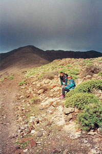
Wir beginnen den Aufstieg ca. 300m unterhalb des neuen Aussichtspunkts und weiter in Richtung zum Berg "La Muda", ein Ort von historischem Interesse durch die dort gemachten Ausgrabungen.
Weiterlesen...

Pico-de-la-Zarza-2Der Aufstieg ist auf einem breiten, guten Weg ohne Schwierigkeiten möglich. Man sollte natürlich Luft haben um von 0 auf 807 m zu steigen.
Mit jedem Meter nähern wir uns dem grandiosen Ausblick. Aber erst einmal beim Zurück schauen sehen wir die Hotelanlagen und den Leuchtturm von Morro. An der Seite wachsen riesige Tabaibabüsche und Kissen von seidigem Goldstern. Die Flechten werden zahlreicher und saftiger, weil dort oben ganz oft das Wolkenmeer uns zwar manchmal die Sicht versperrt, den Pflanzen aber die Feuchtigkeit bringt

Weiterlesen...

Aktuell sind 154 Gäste und keine Mitglieder online

Seitenaufrufe
8472280

biking-hiking2

Spazieren - Wandern & Mountainbiking

BIDI Fuerteventura

BIN06 PORTADA

BIS06 PORTADA

BIDI Fuerteventura

Ein umfassender Inselführer in 6 Sprachen.
Online Edition